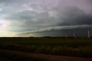
Anatomy of a roll cloud
Storms, storms, storms
A few months into lockdown and the people of Ireland were eventually allowed to roam around a bit. This release culminated with one of the most photogenic thunderstorms I’ve seen during my time on the island.
This particular type of thunderstorm is called an ‘air mass thunderstorm’ as it’s primarily driven by unstable air rising. Notice how the plumes here travel almost vertically upwards.
This vertical movement often stops the cloud from developing further, as the air that reaches the top then cools and falls down. This flow of cool air falling can conflict with the hot air rising, and in effect the system suffocates itself.
However, in this case there likely was plenty of moisture in North Cork’s air for the system to feed on, and perhaps the newly greened fields helped warm the air and setting it in motion.
Also:
I really, really hate that I have to state this, but there’s so much Generative AI-slop out there (yes, even content that pretends to be scientific). Know that I do not use AI for any of my writings, visuals nor thoughts. It’s all written and visualised by a human, meaning me, unless stated otherwise. Therefore, you can always reach out to me if there’s anything factually or grammatically incorrect.
Now, thank you for your interest in this page – I hope you enjoy it!