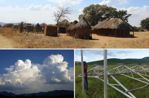
The curse of Northern Europe
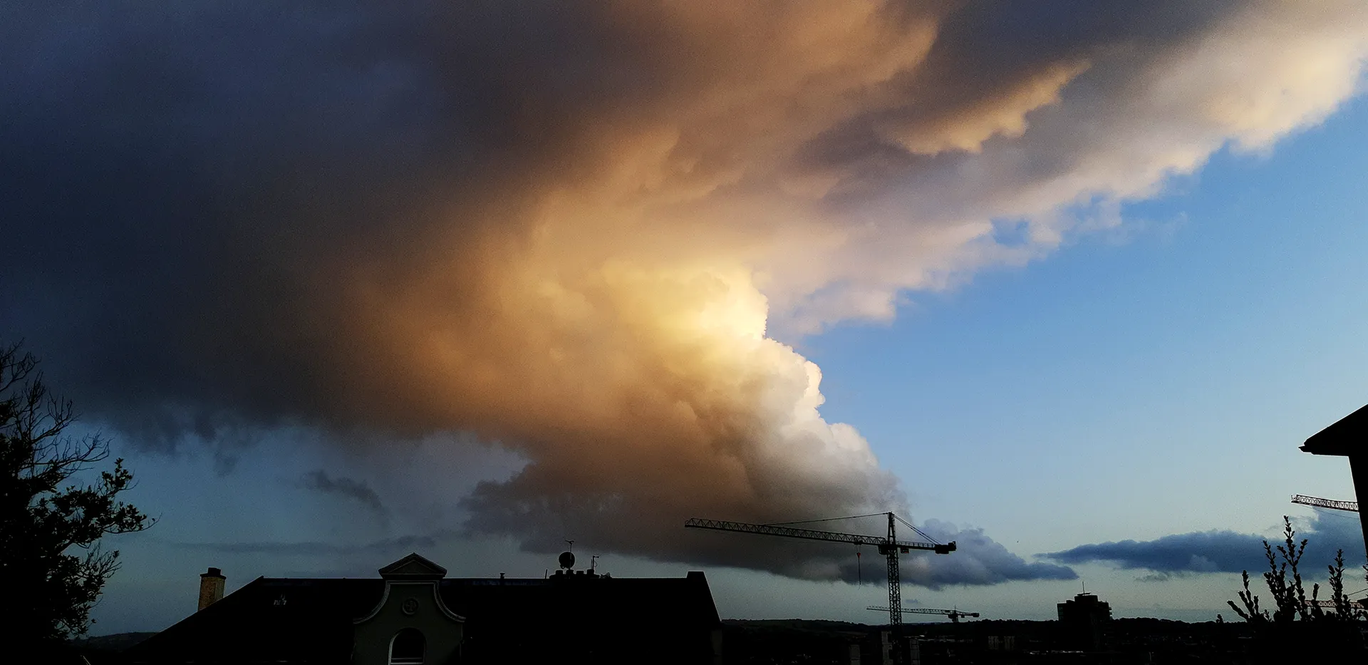
Clouds
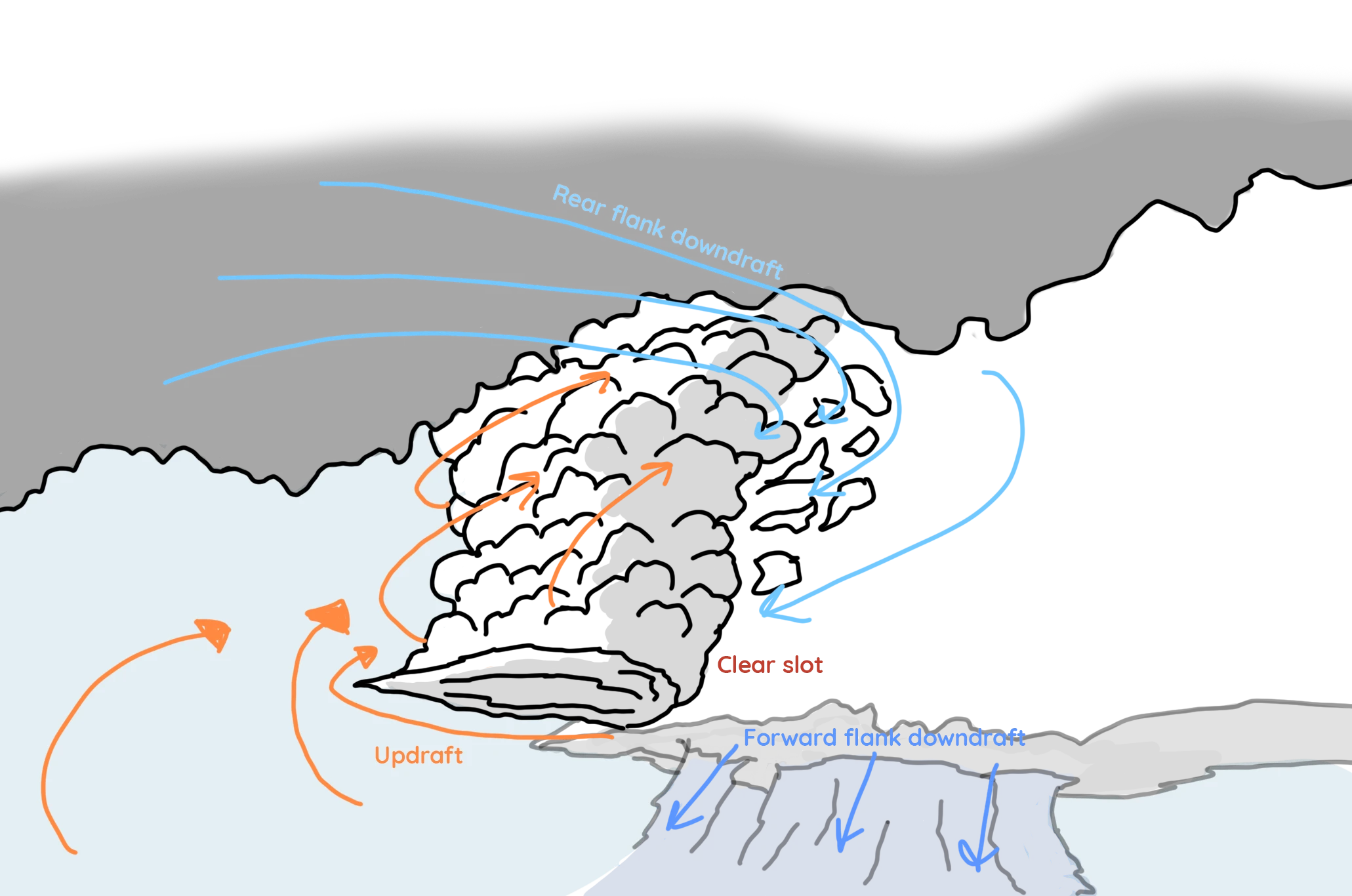
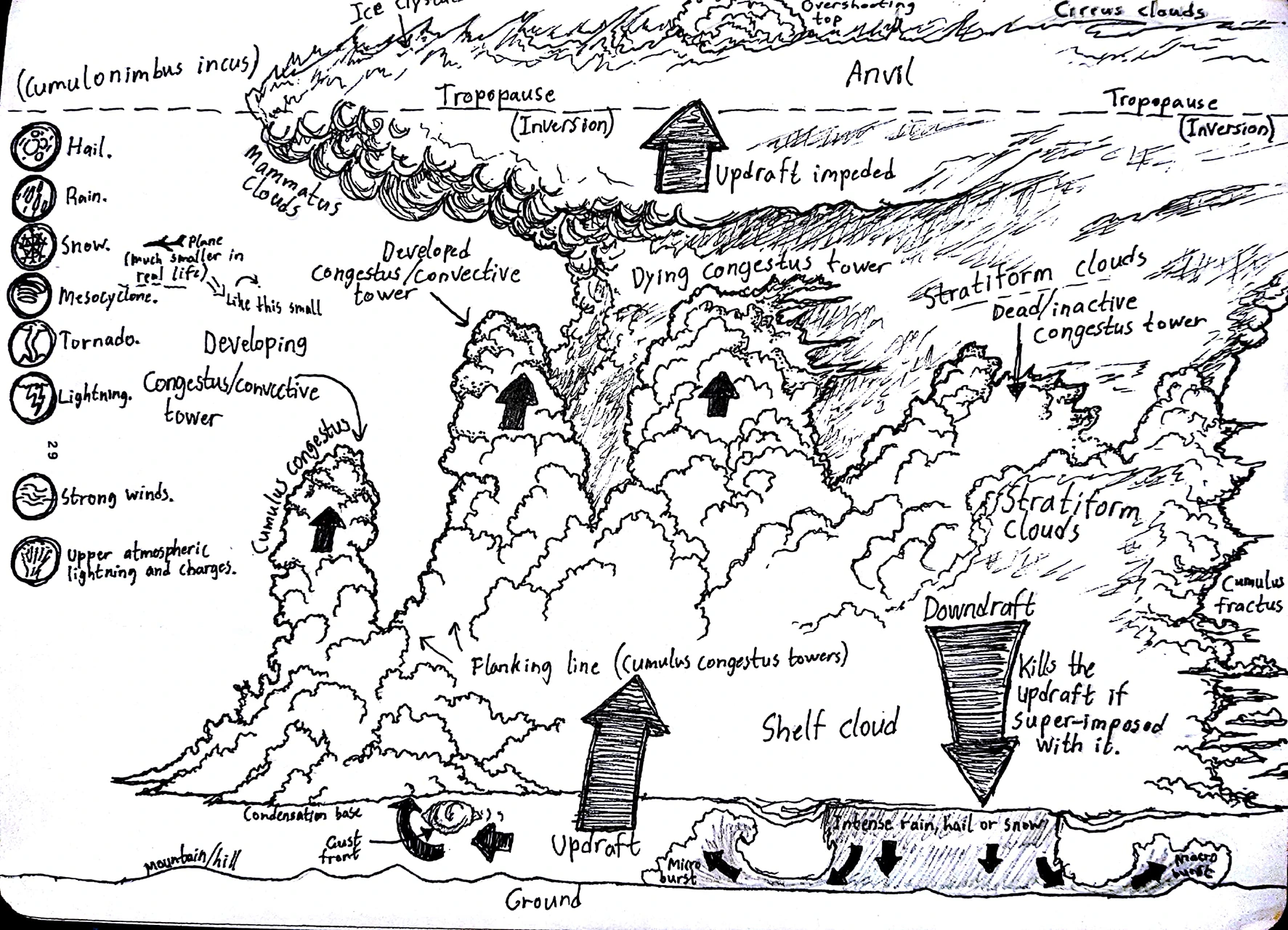
A visual interpretation of the above video. There’s a lot going on…
I don’t want to force anyone into long texts about clouds, however if you want to know how the above comes about, then keep reading… but it’s a long read!
Hot air rises relative to cold air. So when air near the ground is heated, it may rise upwards. But that’s not the whole truth.
In fact, as the temperature changes so does the density of the air. In weather science, the term “air parcel” is used to refer to a volume or bubble of air that has a different temperature than the surrounding air.
So for instance, dark surfaces of asphalt or agricultural fields heat up quite quickly under sunlight. These surfaces then heat the air above them which then makes the air parcel above this warm surface less dense. This lowering of density lifts the air parcel upwards into the sky.
Temperature goes ↑ Density goes ↓ Volume goes ↑
A lot of things can happen as the air parcel rises, but most importantly: it cools a bit which can make the water vapour inside condense turning it into thick volumes of floating water droplets.
We call these thick volumes of floating water droplets: clouds.
A day where there are a lot of air parcels rising far into the atmosphere is typically a day where the atmosphere is quite unstable. Instability here refers to large-scale turbulence as many or big air parcels rise overturning the atmosphere – bringing warm air from the surface up into the colder parts of the atmosphere, and eventually, cold air from high above down to the surface.
Instability in the atmosphere is defined through CAPE (Convective Available Potential Energy). CAPE-values on the 14th of August 2022 were forecast to be at about 700 J/KG at that hour which is high for Ireland.
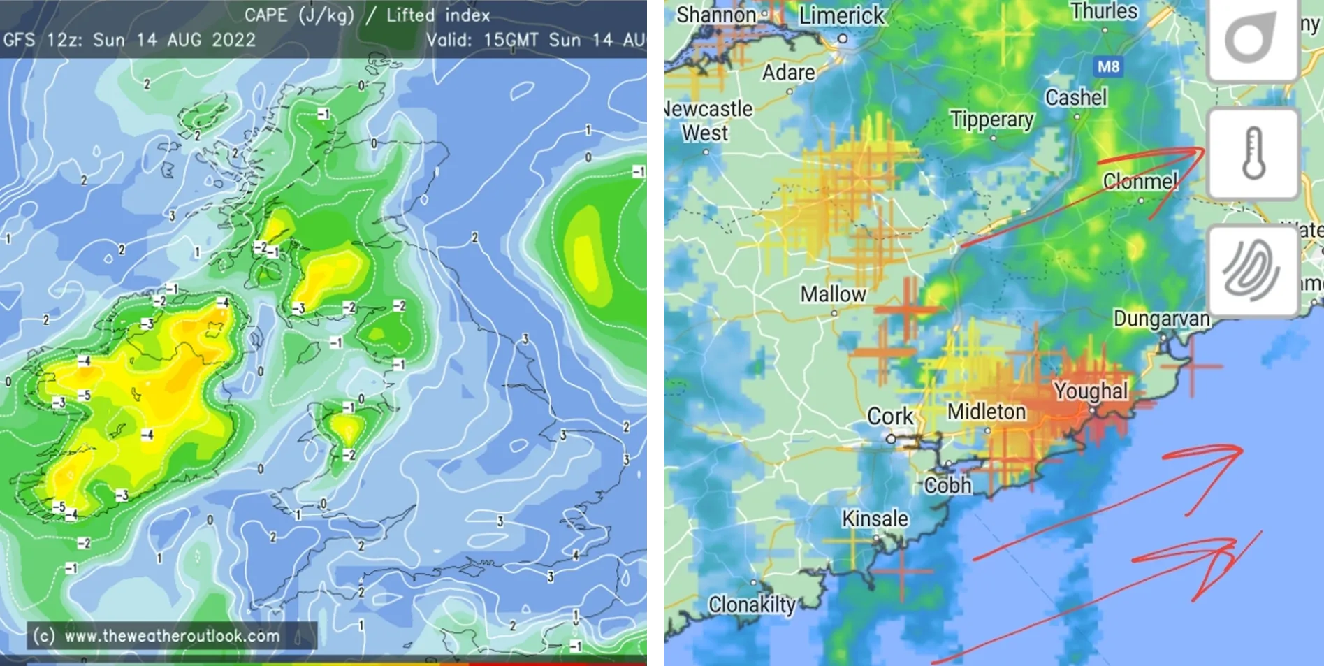
To the left: CAPE-values from The Weather Outlook. Yellow indicates values around 700 J/KG. To the right: radar images from Met Éireann obscured by non-optional lightning symbols. Both from the 14th of August 2022 when the supercell passed over Cork.
The upwards movement of air through heat and density changes is called convection – the C in CAPE.
There’s in an atmosphere certain conditions however that have to be fulfilled for this to happen. These conditions are complex and relate to air humidity, pressure, temperature and perhaps a few other things.
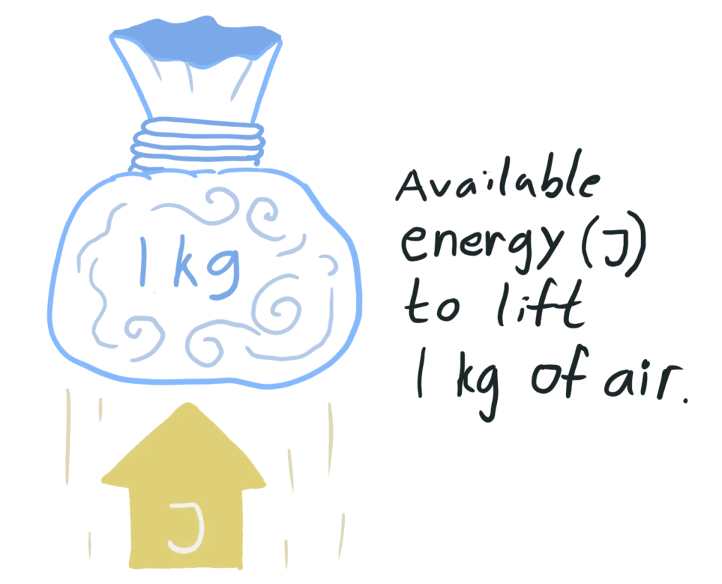
These factors described above can make available potential conditions for convection to happen. Lastly, lifting things requires work, or effort if you will, which in turn requires energy. And so, we get CAPE described as joules/kilogram – in other words: energy per weight of a volume of air.
So a thunderstorm is basically a region of the lower atmosphere destabilising dramatically. Normally, moderate to high CAPE-values are needed for a thunderstorm to develop, but other factors can play in.
And so, thunderstorms form when air near the surface starts rising through the atmosphere condensing a lot of water on the way up. Interestingly, while the air parcel cools as it ascends through the atmosphere, it also simultaneously heats up!
Condensation as a phase change is interesting to narrow in on: for every puff of water vapour that cools and becomes a drop of water, a bit of heat is given off. So when millions and millions of droplets are formed inside a developing cloud, the cloud also heats up a tiny bit. This can make the cloud travel upwards faster and pass through any boundaries along the way.
This process is complex, but it’s a significant amplifier of the updraft in a thunderstorm.
So we’ve made the thunderstorm.
Now you need to spin it. Rotation is another thing that’s abstract to visualise or describe. Key is the concept of conservation of angular momentum. That’s basically how rotation and rotational energy can be stored and transferred as motion – even after what applies the momentum is gone.
In the atmosphere, layered changes in wind speed can make local volumes of air spin horizontally. A classical example to show this involves taking a pencil between two hands and sensually sliding your hands against each other – each hand in opposite direction or by holding one hand still. The pencil started rotating because of this sliding. This is called shearing.
You may consider it uncomfortably windy on a regular autumn day with 12 m/s winds. However, about ten kilometres above our heads, you’ll find consistently above-hurricane wind speeds. In contrast, wind speeds are usually a lot slower nearer the surface due to friction between the air and the ground.
So when winds at different altitudes have different speeds, the air in between them may rotate. A long tunnel of rotating air with a horizontal axis may develop, like the rotating pencil above.
Now, this tunnel of horizontally rotating air can get sucked up into the updraft of thunderstorm. If these two are timed well, the horizontally-oriented tunnel of air will conserve its angular momentum and, in a sense, transfer it to the updraft.
The whole updraft area may start rotating as seen in the Cork supercell.
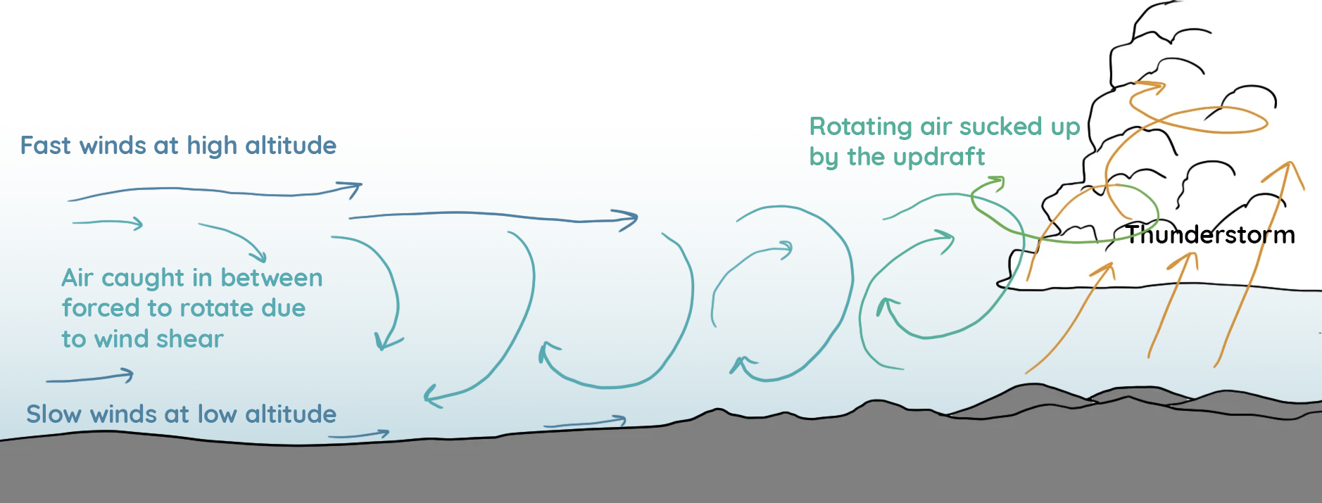
This can make the updraft more powerful! Likely because it both inherited angular momentum from the rotating air but also has more space to move in. In any case, air in rotation is hard to get an intuitive understanding of.
It could. But often does not.
Supercells happen all the time in the summer months of North America, but often do not cause tornadoes. Making a tornado requires certain conditions that even storm chasers and weather experts don’t fully understand.
On rare occasions, tornadoes can form outside of these specific environments as well, which is even more puzzling. But if a tornado develops, it does so near the clear slot-area that I pointed out in the interpretation.
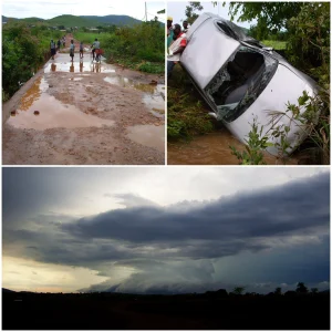
We definitely needed to see this one again!
Near the clear slot, the air here may start rotating locally due to interactions between three air masses: the updraft, the forward flank downdraft and the rear flank downdraft.
The rear flank downdraft rotating along with the updraft is what creates the clear slot: a narrow area of air falling down in between the updraft and the forward flank downdraft. It’s in this interaction that a tornado can form. How this happens precisely is still a bit of a mystery.
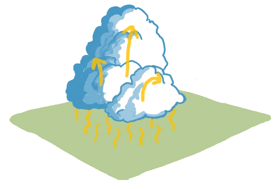
A narrow updraft column over Cork from 2019.
Notice the tilting of the updraft column: That is essential for a strong and lasting thunderstorm to develop.
It took me a few years to understand this intuitively, but seeing it in action in real-life on the 14th of August 2022 made it make more sense. Especially as I could take my time observing and recording these processes.
I won’t talk about tornadoes, because I’ve never seen one except a good few waterspouts.
Music licensed from audiojungle.net.
References:
Finley C. A., Elmore M., Orf L. & Lee B. D. 2022. Impact of the Streamwise Vorticity Current on Low-Level Mesocyclone Development in a Simulated Supercell. Geophysical Research Letters, Vol. 50, Issue 1. DOI: 10.1029/2022GL100005
M. L. D. Johannes, 2017. Tilting of Horizontal Shear Vorticity and the Development of Updraft Rotation
in Supercell Thunderstorms. Journal of the Atmospheric Sciences. Vol. 74. Issue 9. PP. 2997–3020. DOI: https://doi.org/10.1175/JAS-D-17-0091.1
Shabbott C. J. & Markowski P. M., 2006. Surface In Situ Observations within the Outflow of Forward-Flank Downdrafts of Supercell Thunderstorms. Monthly Weather Review. Vol. 134. PP. 1422–1441. DOI: https://doi.org/10.1175/MWR3131.1
https://www.met.ie/
https://www.theweatheroutlook.com/
https://www.e-education.psu.edu/meteo3/l9_p5.html